14. Orkney Archaeology (August 2022)
This describes a short but intense holiday I organised to explore in general, the majority of accessible pre-historic cairns and other sites in Orkney.
This page is arranged as an itinerary with accompanying photos, followed by the extensive research I carried out in order to be able to cram as much as possible into just 5 days. Our trip was from Monday 22/08 to Friday 26/08 but there is no reason why the itinerary cannot act as a template for other dates.
Timeline of prehistoric Scotland:
https://en.wikipedia.org/wiki/Timeline_of_prehistoric_Scotland
Etymology
A broch is from Old Norse ‘Borg’ meaning ‘stronghold' and is a kind of Iron Age roundhouse
A brough may mean or refer to an area, enclosure, round tower or outer wall of a feudal castle
A Bu is a farm, from 'bygging' meaning 'building' from Norse 'byggja' meaning to settle or to build
A cairn is a pile of stones often used as a burial mound. From Scottish Gaelic: càrn, 'heap of stones'
A cist is an ancient coffin or burial chamber made from stone or a hollowed tree
A ness is a narrow piece of land projecting into the sea (i.e. headland)
Holm pronounced 'ham' is a corruption of Old Norse homn for 'haven' or 'good anchorage'
Howe is Norse for hill (e.g. Maeshowe)
Knowe is Scottish for knoll: a mound or small hill
This webpage is divided up into the following sections
1. Suggested itinerary
2. Chambered cairns
3. Neolithic & Iron Age sites in Orkney & Rousay
4. Orkney Tingwall to Rousay island ferry prices & times
5. Viking sites
6. Tide timetables
7. Ticket prices and links to payment
8. Best sea caves & views
9. Other places on itinerary
10. Other places further out
11. Food
12. Aurora Borealis / Northern Lights
13. Excavations
14. Maps & books
15. Climate
16. Expenditure
17. Shetland
1. SUGGESTED ITINERARY
IMPORTANT INFORMATION
1. Ferry Scrabster to Stromness, NorthLink Ferries
Ferry Kirkwall to Aberdeen, NorthLink Ferries
NorthLink Ferries operates a ticketless system, YOU NEED CONFIRMATION EMAILS TO BOARD.
Check-in opens 90 minutes prior to departure at Kirkwall, Stromness and Scrabster.
Check-in closes 30 minutes prior to departure at all ports.
Car drivers are recommended to check-in at least 1 hour prior to departure
https://www.northlinkferries.co.uk/the-journey/check-in-and-boarding/
https://www.northlinkferries.co.uk/the-journey/kirkwall/
2. The Tingwall/ Rousay Island ferry can take up to 10 cars at any time. (max 95 passengers)
If taking your vehicle it is advisable to book in advance: Tigwall Booking Office 01856 751360.
http://www.aroundrousay.co.uk/gettinghere.shtml
3. Orkney Fish CLOSES AT 1pm ON MONDAY (Tue-Fri 4pm) Garson Park, Stromness KW16 3BL, Tel 01856850870
4. Orkney mobile coverage is poor but see if you can access this page on a mob.
5. Enter 'place name to place name by car' into Google and it will give route, miles and duration.
6. Post/Grid = Post Code or National Grid map reference
7. N (place) means North of (place) etc, SE = South East etc. 1m = 1 mile
8. The Dwarfie Stane on the map below left is not in the itinerary (but is detailed under RESEARCH)
9. Generally sites do not have food or toilets, therefore take food and use toilets if you see them.
ITINERARY MAP


Left: Orkney wildlife on blackboard in Maeshowe Visitor Centre
ITINERARY - SUMMARY (refer to map above)
1 22/08 Monday
8:45 Ferry to
NORTH ORKNEY
Old Man of Hoy stack
Birsay Earl's Palace
Fursbreck pottery
2 23/08 Tuesday 3 24/08 Wednesday 4 25/08 Thursday 5 26/08 Friday
10:40 Ferry to
CENTRAL ORKNEY ROUSAY ISLAND WEST ORKNEY EAST + SE ORKNEY
Maeshowe Taversoe Tuick Skara Brae Cuween Hill
Stenness Blackhammer Skail House Rennibister Earth Hs
Barnhouse Settlement Knowe of Yarso Yesnaby Wideford Hill
Ness of Brodgar Knowe of Lairo Castle sea stack J.Gow 58.8°N +
Ring of Brodgar Midhoe Broch of Borwick Italian chapel OR
Unstan Midhoe Broch Orkneyinga Saga +
Stromness Museum Heritage Walk Earl's Bu
Swando Excavation Wireless museum
17:30 Ferry back St Magnus cathedral
Bishop/Earl palaces
Orkney museum
23:45 Ferry Scotland
ITINERARY - DETAILED
Site photos below are deliberately chosen to avoid giving too much away, of course we entered everything
21/08 Sunday
Buy essential groceries and follow the A9 to our pre-booked evening accommodation in Thurso.
Take a short diversion to John O'Groats first. Six miles SE is Muckle Skerry island, the mysterious twin white towers are its lighthouse and foghorn: https://www.nlb.org.uk/lighthouses/pentland-skerries/


[MAP: 1] 22/08 Monday - NORTH ORKNEY
Catch 8:45am ferry from Scotland: Scrabster to Stromness (I recommend the onboard breakfast).
Get there at least 07:45 for car boarding [See Note 1 above]
En-route the ferry passes the Old Man of Hoy sea stack off the western coast of Hoy island not long before its approach to Stromness. The stack is visible from the right hand side of the ferry:


10:15 Arrive in Stromness
Drive 18 miles from Stromness to Broch of Gurness (32 mins) [See Note 5 above]:
Score hrs Site TIME Description Location Post/Grid Walk? Price
4.8/5( 410) 5pm Broch of Gurness 11:30 Iron age village North KW17 2NH 30m £7.00


Drive 11 miles from Broch of Gurness to Brough of Birsay off the A966 (20 mins).
At the end of the A966 is the ruins of the 16th century Birsay Earl's palace which can be visited before or afterwards, depending on how close the tide is to covering the causeway. The latter is reached by turning right at the end of the A966 and following the B road about 0.5 mile to the car park.
'The causeway should be passible 2 hours either side of low tide'
On 22/08/22 Low Tide was 12:23 and High Tide was 18:39 - see [6. TIDE TIMETABLES]
Score hrs Site TIME Description Location Post/Grid Walk? Price
4.5/5( 310) X Brough of Birsay TIDE Viking Island North West KW17 2LX tidal path FREE
4.4/5( 359) 24h Birsay Earl's Palace ruins from 1500s North West HY 248 277 Nearby FREE


Where else?
Drive 8 miles south from Brough of Birsay to Fursbreck pottery on the A986 (16 mins)
(the actual closing time is 5:51pm):
Score hrs Site Description Location Post/Grid
4.9/5( 8) 5pm Fursbreck pottery pottery & shop Centre KW17 2LB
Drive 8 miles back to Stromness (14 mins)
Check into at our accommodation (4 nights) at Flotta Eastbrae Cottages, Stromness, KW16 3HS
Check-in Monday 22 August 2022 (17:00 - 00:00) Tel.(+44) 7834 837 512
This is excellent quality accommodation, highly recommended.
[MAP: 2] 23/08 Tuesday - CENTRAL ORKNEY
Visit the 'Orkney Fish' shop at KW16 3BL Tue-Fri 9am to 4pm (Mon closes 1pm) for our dinner.
Visit first thing today, or last thing depending upon available time.
Drive 4 miles from Stromness via A965 to Maeshowe Visitor Centre on RHS for tour bus to Maeshowe
(must arrive 15 mins early for bus)
Maeshowe - COLLECT PAID TICKETS AT SITE TICKET OFFICE ON ARRIVAL
Score hrs Site TIME Description Location Post/Grid Walk? Price
3.9/5( 23) var Maeshowe 12:00 big covered cairn 4m N Stromness KW16 3LB bus incl. £9.50


The Barnhouse stone (above centre) is 750m SW of Maeshowe, on the right side off the A965. We can go back for it now before we continue, or catch it another day when we again travel along this road.
Turn right out of Maeshowe Visitor Centre and drive another 0.5 mile on A965, then take left turn onto B9055 heading north to visit the following sites.
Note 1. There are no toilets at the sites below; use the ones at Maeshowe Visitor Centre before leaving.
Note 2. The Ness of Brodgar dig is well worth visiting, but is closed for winter from mid August, after which it is covered by tarpaulin and hidden from view.
Score hrs Site TIME Description Location Post/Grid Walk? Price
4.6/5( 748) 24h Stenness standing stones SW middle HY 306 126 FREE
4.6/5( 27) 24h Barnhouse settlement mid level ruins ditto HY 306 126 FREE
DRIVE PAST IT X Ness of Brodgar DIG low level ruins ditto CLOSED Aug 19+ FREE
4.6/5(1312) 24h Ring of Brodgar standing stones ditto KW16 3JZ FREE


Most photos of Brodgar ring show its impressive height. Here's a panoramic, but still with some missing:

Drive back south on A965 to T junction, turn right towards Stromness and after 1.7 miles turn right onto a small track leading to the free car park for Unstan cairn (there is a small brown tourist signpost to Unstan on the A965).
Score hrs Site TIME Description Location Post/Grid Walk? Price
4.4/5( 80) 24h Unstan covered cairn 2m NE Stromness HY 283 117 FREE


If we didn't make it to the fish shop this morning, we can visit it now and quickly drop off the food at our accommodation before heading for the museum:
Drive to Stromness museum to see the Cairns exhibition running from May to October 2022.
Check out the museum online for other exhibitions. OPENING TIMES VARY (Tue 10am-1pm and 1.45pm-5.00pm)
https://www.stromnessmuseum.org.uk/whatson
Score hrs Site TIME Description Location Post/Grid Walk? Price
4.5/5( 251) var Cairns Exhibition Stromness Museum Stromness KW16 3DH £5/£4
Drive back to our accommodation in Stromness
[MAP: 3] 24/08 Wednesday - ROUSAY ISLAND (RI)
Ferry times 10:40 & 17:30 give ~6 hours on the island
PAY ON ARRIVAL: 2022 small car £27.20 + £8.50 per person
If the weather is bad but Thursday is ok and no spaces left
for a car, go as passengers & walk to first sites instead.

Drive 14 miles from Stromness to Tingwall ferry at KW17 2HB (21 mins):
10:30 catch ferry 10:40 from Tingwall (next earlier one is 1st at 08:20, next later one is 11:50)
NOTE - THESE SITES ARE INLAND OFF THE ROAD, FOR ACCESS SEE MAPS IN RESEARCH SECTION
Score hrs Site Description Location Post/Grid Walk? Price
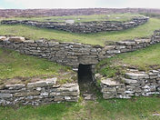
4.9/5( 9) 24h Taversoe Tuick 3 tombs RI SE coast HY 426 276 100 metres FREE


Score hrs Site Description Location Post/Grid Walk? Price
4.4/5( 13) 24h Blackhammer 7 stalled cairn RI SE coast HY 414 276 CLIMB INSIDE FREE


Score hrs Site Description Location Post/Grid Walk? Price
4.8/5( 11) 24h Knowe of Yarso covered cairn RI S coast HY 404 279 1/2 mile FREE


Score hrs Site Description Location Post/Grid Walk? Price
4.8/5( 8) 24h Knowe of Lairo covered cairn RI S coast HY39922796 1/2 mile FREE


MIDHOE & BROCH
This is the biggest site, finish here and work back towards the ferry (may do Heritage Walk too):
This is 5 miles west of the ferry on the B9064 with parking on left for 5 cars.
Score hrs Site Description Location Post/Grid Walk? Price
4.6/5( 11) 24h Midhoe tomb & cairn SAME PLACE KW17 2PS SAME PLACE FREE


Score hrs Site Description Location Post/Grid Walk? Price
4.7/5( 35) 24h Midhoe Broch round house RI SW coast KW17 2PS 1/3 mile FREE


from Midhoe you can start a 3-mile round trip Westness Heritage Walk southeast along the beach to Westness Farm, covering a number of other ruins including St Mary's church and a newly discovered Viking drinking hall. It also passes the Swando Excavation. An inland farm track provides a bland but faster return route. There are no photos as we did not undertake this walk.
The Swando Excavation is on the shore east of Midhoe and in 2022 was open from June 20th to August 12th
unfortunately out of our dates. The dig is of a large Neolithic settlement and Viking longhouse. The Kirkwall museum in Orkney has many artifacts and information on the Swandro dig area.
There are no photos as the excavation was closed when we were there.
Score hrs Site Description Location Post/Grid Walk? Price
5.0/5( 19) 5pm Swando Excavation Neolithic/Viking RI SW coast HY 3753 2966 1/2 mile FREE
17:00 Catch LAST ferry 17:30 (suggest arrive 17:00) back to Tingwall (next earlier one is 15:20)
Drive back to our accommodation in Stromness
[MAP: 4] 25/08 Thursday - WEST ORKNEY
BOOKED 10:30 ticket time on 29/06/22
Drive 7 miles from Stromness to Skara Brae (12 mins): (it's also 5.5 miles North of Ness of Brodgar)
The site is on the shore of a nice long beach about 1/3 mile from the visitor's centre arrival point.
Score hrs Site TIME Description Location Post/Grid Walk? Price
4.7/5(1508) var Skara Brae 10:30 pre-hist village W coast mid KW16 3LR £12/£9.50


Skail house is included in the price paid for Skara Brae and is located along the walk from the visitor's centre. This mansion is a museum of its own history with many artefacts across the ages.
Score hrs Site TIME Description Location Post/Grid Walk? Price
4.4/7( 84) var Skail House Mansion in use SAME KW16 3LR with SB


Drive 5 miles from Skara Brae to the car park at the end of Yesnasby road off the B9056 (9 mins):
The car park is on the seaside clifftop ~4 miles S of Skara Brae.
Rest of day:
Explore Yesnaby shoreline renowned for its spectacular old red sandstone coastal cliff scenery which includes sea stacks, blowholes, geos and frequently boiling seas.
The high res OS map says there is a fort, cairn, cavern and waterfall, and 2 caves below the cliff car park. A map screenshot of these is below in SECTION 8. BEST SEA CAVES AND VIEWS IN ORKNEY.
Note: It is not possible to explore the caves along the shore as the tide does not go low enough.
Score hrs Site TIME Description Location Post/Grid Walk? Price
N/A 24h Yesnaby sea stack/puffins off Yesnasby Rd HY221161 FREE


Score hrs Site TIME Description Location Post/Grid Walk? Price
5.0/5( 326) 24h Castle sea stack famous sea stack 600 mtr N Yas Rd KW16 3LP FREE


Score hrs Site TIME Description Location Post/Grid Walk? Price
4.6/5( 14) 24h Broch of Borwick round house 700 mtr N Yas Rd HY22411678 FREE


Drive back to our accommodation in Stromness.
[MAP: 5] 26/08 Friday - EAST + SE ORKNEY
Drive 8 miles on A965 from Stromness to Cuween Hill (15 mins):
Score hrs Site Description Location Post/Grid Walk? Price
4.6/5( 94) 24h Cuween Hill chambered cairn 2m W Kirkwall HY 364 128 1m S A965 FREE


Drive 3 miles EAST on A965 to Rennibister Earth House (6 mins):
Drive to KW15 1TX then continue 150m to track on left to Earth House.
Score hrs Site Description Location Post/Grid Walk? Price
4.3/5( 19) 24h Rennibister Earth Hs undergrnd passage 2m W Kirkwall KW15 1TX N off A965 FREE
No photos as we did not have time to visit this.
Drive WEST on A965 to Wideford Hill scenic view (10 mins) then walk 500 metres off road AS FOLLOWS:
Head back and turn RIGHT onto A965 and drive WEST 0.8 mile and take 1st left onto (UNIDENTIFIED)
"Zion's Loan" for 430m (past sign to Wideford Hill Cairn). At T junction turn LEFT onto (UNIDENTIFIED)
Old Finstown Road and drive EAST ~2 miles to turning on left with (/) road signs each side, see Google Maps photo under RESEARCH: SECTION 3. WHERE TO VISIT: Wideford Hill Cairn, below. Full route map there
Note: it is not possible to park on the A965 below the hill.
Score hrs Site Description Location Post/Grid Walk? Price
4.4/5( 33) 24h Wideford Hill chambered cairn 2m W Kirkwall HY 409 122 CLIMB DOWN FREE


Kirkwall is just another 3 miles east however at this point there are a couple of options. This being our last day we chose OPTION 1, drove through Kirkwall without stopping and visited the Italian chapel on Lambholm island, then returned to Kirkwall where we visited the Wireless museum, cathedral, Bishop's & Earl's palaces and the Orkney museum.
Options are listed below.
OPTION 1
Head back from Wideford Hill viewing point and turn LEFT onto Old Finstown Road leading to Kirkwall approx. 2.5 miles, then turn onto the A961 and drive 6 miles south to The Inn at Holm KW17 2RT, for a short coffee and cake break and scenic view.
Next, follow the A961 across the small causeway to tiny Lambholm island. Take the first left and on the corner visit the J.Gow '58.8° North' shop for the Rum distillery located behind it, also hosting Orkney Wine Company produce and offering free tasting.
Score hrs Site Description Location Post/Grid
3.6/5( 12) 5pm J.Gow '58.8° North' rum & wine shop bridge end KW17 2SF
200 yards on at the end of this road, visit the famous Italian catholic Chapel built in WW2 by Italian POWs using scavenged materials and housed in a military hanger. Note: parking is very limited and it's usual for cars to park on the side of the road leading almost back to the shop.
Score hrs Site Description Location Post/Grid
4.6/5(1473) var Italian chapel Built by WW2 POWs end of road KW17 2SF


OPTION 2
Head back from Wideford Hill viewing point and turn RIGHT onto Old Finstown Road leading into Gladness Road for ~2 miles until T junction then turn right onto A964 and drive south 7.3 miles to Orphir Kirk, then turn left onto Gyle Road ~1.2 miles south to the Orkneyinga Saga Centre. Earl's Bu is nearby.
Alternatively, head for this off the A965 just after the Bridge of Waith and afterwards do the hill cairns above following the reverse of the route to Wideford Hill.
Score hrs Site Description Location Post/Grid Walk? Price
4.4/5( 34) 24h Orkneyinga Saga Cntr A/V pres SE coast KW17 2RD - FREE
4.0/5( 68) 24h Earl's Bu limited ruins SAME PLACE KW17 2RD - FREE
No photos as we did not have time to visit this.
After either option, head back to Kirkwall. Kirkwall is relatively small and has many car parks.
The small wireless museum is close to the harbour and has WW2 memorabilia as well as general history, and a very knowledgeable proprietor. In the front window are two large robot sculptures, more info here:
https://robomofos.com/about/
Score hrs Site Description Location Post/Grid Walk? Price
4.5/5( 148) 4pm Wireless museum Lots of radios mid SE coast KW15 1LB - FREE


St Magnus cathedral, the Bishop's and Earl's palaces and the Orkney museum are all located close to each other, about 400m inland from the harbour.
Score hrs Site Description Location Post/Grid Walk? Price
4.5/5(1889) 5pm St Magnus cathedral 12th century mid SE coast KW15 1NX - FREE


The Earl's palace was built in 1601-1606 as an improvement of the Bishop's palace which was build mid-1100. They include the large tower to the right (south) of the cathedral. You can walk around the grounds but have to buy a ticket to enter the buildings. In 2022 it was possible to walk around the outside top of the tower (see photo below far right) but this may no longer be the possible.
Score hrs Site Description Location Post/Grid Walk? Price
4.5/5(317) 5pm Bishop's/Earl's palace 12th/17th century mid SE coast KW15 1PD - £7.50


The Orkney museum has many Viking artefacts and is diagonally opposite the cathedral front door.
Score hrs Site Description Location Post/Grid Walk? Price
4.5/5( 617) 24h Orkney museum Vikings et al mid SE coast KW15 1DH - FREE


7:30 Dinner (12-9pm)
Helgi's Pub restaurant
14 Harbour Street,
Kirkwallm
KW15 1LE,
Tel 01856 879293
Upstairs windows look out onto the harbour.

Catch ferry Kirkwall to Aberdeen leaving 23:45 overnight 4-bed cabin
Get there at least 22:45 for car boarding [See Note 1 at top]
27/08 Saturday
Ferry arrives in Aberdeen at 07:00
RESEARCH
2. CHAMBERED CAIRNS
Here's a good link describing Orkney's chambered tombs, listed below:
http://www.orkneyjar.com/history/tombs/index.html
Maeshowe GOOD (grass covered chamber + 3 tiny cavities)
Isbister (tomb of the eagles) PERMANENTLY CLOSED
Cuween GOOD
Wideford Hill GOOD
Unstan GOOD
Crantit TOO SMALL & NO SIGN OF AVAILABILITY (in a ploughed field)
Midhowe (Rousay) GOOD
Blackhammer cairn GOOD (on Rousay island between Tuick & Yarso)
Dwarfie Stane ROUND TRIP TAKES BEST PART OF A DAY
3. WHERE TO VISIT - Neolithic & Iron Age sites in Orkney & Rousay
These are the main sites. There are smaller historical things dotted about, visible by zooming into Google's map.
We will visit everything listed as 'YES' below this map (+YES especially)
Google map below shows Orkney prehistoric sites. Pay sites (£ on map) may close for lunch 12-1pm:
https://www.google.com/maps/search/orkney+prehistoric+sites%23/@58.967239,-3.3427479,10.25z
Not all site names are visible on this screenshot so you need to open the real map above.
Zoom in to reveal ferry routes, towns, food, etc. Right-click Google Maps to measure distances.
Here is a faster loading and higher resolution satellite map:
https://satellites.pro/Orkney_map.UK#59.134111,-3.309460,15
Archaeological archive site - search here for even higher resolution photos:

SEE TICKETS & ADDITIONAL NOTES ON MEASHOWE / SKARA BRAE / BROCH OF GURNESS BELOW VIKINGS SECTION.
Key:
Google reviews score on left
Tickets 'concession' = age 65+ is 2nd value e.g. £10/£5
hrs: 5pm = closing time / ££ = see prices / 24h = free & open 24 hours / X = permanently closed
PLEASE CLICK ON THE LINKS BELOW TO SEE PHOTOS OF WHAT'S THERE
ORKNEY MAIN ISLAND (11 places)
Score hrs Site Description Location Good? Price
4.8/5( 410) 5pm Broch of Gurness iron age village North by Rousay +YES SHUT Wed+Thu £7/£5.50
https://www.historicenvironment.scot/visit-a-place/places/broch-of-gurness/overview/
https://www.historicenvironment.scot/visit-a-place/places/broch-of-gurness/prices-and-opening-times/
Evie, KW17 2NH
4.7/5(1508) ££ Skara Brae Skail Hs prehistoric village W. coast mid YES £12/£9.50
Skara Brae, Sandwick, Orkney, KW16 3LR, National Grid reference: HY 231 188
Ticket also includes Skail House:
https://www.visitscotland.com/info/see-do/skara-brae-prehistoric-village-p247671
https://www.historicenvironment.scot/visit-a-place/places/skara-brae/
https://www.historicenvironment.scot/visit-a-place/places/skara-brae/prices-and-opening-times/
4.6/5( 14) 24h Broch of Borwick clifftop round house 1 mile south of Skae Brae bit naff but nearby
https://www.orkney.com/news/broch-of-borwick
4.4/5( 80) 24h Unstan covered cairn SW middle YES FREE
About 3.5m North East of Stromness on the A965. Grid ref HY 283 117
https://www.historicenvironment.scot/visit-a-place/places/unstan-chambered-cairn/
4.6/5(1312) 24h Ring of Brodgar standing stones SW middle YES Very tall FREE
Brodgar B9055, Stromness KW16 3JZ
https://www.historicenvironment.scot/visit-a-place/places/ring-of-brodgar-stone-circle-and-henge/
N/A X Ness of Brodgar DIG low level ruins SW middle N/A CLOSED Aug 19+ FREE
https://www.nessofbrodgar.co.uk/
https://www.nessofbrodgar.co.uk/visit/
3.9/5( 23) ££ Maeshowe big covered cairn SW middle COVID ISSUE ? £9.50/£7.50
Stenness KW16 3JY Open 9:30 to 12:00 and 13:00 to 17:00
https://www.nessofbrodgar.co.uk/around-the-ness-maeshowe/
https://www.historicenvironment.scot/visit-a-place/places/maeshowe-chambered-cairn/prices-and-opening-times/ COVID ISSUE - SEE TICKET NOTES BELOW VIKINGS
4.6/5( 748) 24h Stenness standing stones SW middle
About 5m north east of Stromness on the B9055. Parking available. Grid ref HY 306 126
https://www.historicenvironment.scot/visit-a-place/places/stones-of-stenness-circle-and-henge/
4.6/5( 27) 24h Barnhouse settlement mid level ruins SW middle YES by Stones FREE
https://en.wikipedia.org/wiki/Barnhouse_Settlement
4.6/5( 94) 24h Cuween Hill chambered cairn E. coast mid YES FREE
Tomb of the dogs. Located between Kirkwall and Finstown, signposted from Finstown Road,
parking available. Grid ref HY 364 128
https://www.historicenvironment.scot/visit-a-place/places/cuween-hill-chambered-cairn/
4.3/5( 19) 24h Rennibister earth hs underground passage SE YES FREE
About 4.5m WNW of Kirkwall on the A965. It is located in the grounds of Rennibister Farm.
Grid ref HY 397 127, Kirkwall KW15 1TX
https://www.historicenvironment.scot/visit-a-place/places/rennibister-earth-house/
4.4/5( 33) 24h Wideford Hill chambered cairn SE +YES CLIMB DOWN FREE
https://www.historicenvironment.scot/visit-a-place/places/wideford-hill-chambered-cairn/
'HARD TO FIND' - THIS PINPOINTS IT ON GOOGLE MAPS (Change to satellite view & zoom in):
https://www.google.com/maps/place/Wideford+Hill+Cairn/@58.9916788,-3.0332205,16z/data=!4m7!3m6!1s0x489b01ef02f8e2b9:0x7ba7442516757f1d!8m2!3d58.9918751!4d-3.030065!9m1!1b1?hl=en
Drive 4 miles to Wideford Hill scenic view (10 mins) then walk 500 metres off road but it's worth it.
This link shows the car route (the A965 doesn't have any parking places) and our route on foot. Note Wideford hill is large and in places steep. The path is well trod and easily followed.
THE ROAD TO THE SCENIC CAR PARK IN NOT IDENTIFIED SO BELOW IS A PHOTO OF IHE TURNING ON THE LEFT (/):


N/A X Quanterness chambered-cairn SE NOT OPEN TO PUBLIC
https://www.nessofbrodgar.co.uk/quanterness-chambered-cairn/
ROUSAY ISLAND (6 places)
A small island above Orkney) [15 known chambered tombs]
Thesis by J.Clark; excellent digitised imagery of pre-historic and Norse sites on Rousay Island:
https://lup.lub.lu.se/luur/download?func=downloadFile&recordOId=9036139&fileOId=9036145
GOOGLE MAP BELOW SHOWS ENTIRE SITE ROUTE ALONG THE B9064 FROM THE FERRY TO MIDEHOE BROCH

Taversoe Tuick & Blackhammer
There are parking areas on the RH side of the B9064 besides these 2 sites that are inland of the road.
They are the first parking areas on the road after the ferry.
4.9/5( 9) 24h Taversoe Tuick 3 tombs SE coast YES FREE
0.5 mile west of ferry. Grid ref HY 426 276
https://www.historicenvironment.scot/visit-a-place/places/taversoee-tuick-chambered-cairn/
4.4/5( 13) 24h Blackhammer 7 stalled cairn SE coast +YES CLIMB INSIDE FREE
On B9064 on island of Rousay, 0.5 mile west of Tiversoe Tuick. Steep & can be muddy. Grid HY 414 276
https://www.historicenvironment.scot/visit-a-place/places/blackhammer-chambered-cairn/
https://en.wikipedia.org/wiki/Blackhammer_Chambered_Cairn

--------------------------------------------------------------------------------------------------------
These Knowes are mounds with open entrances. The entrance to Knowe of Lairdo is particularly small.
Both mounds are located a few 100m or so inland from the B9064.
Score hrs Site Description Location Good? Walk? Price
4.8/5( 8) 24h Knowe of Lairo covered cairn South coast YES 1/4 mile FREE
https://www.megalithic.co.uk/article.php?sid=27557
https://www.tripadvisor.com/ShowUserReviews-g551786-d10749200-r701901179-Knowe_of_Yarso_Chambered_Cairn-Rousay_Orkney_Islands_Scotland.html#REVIEWS
4.8/5( 11) 24h Knowe of Yarso covered cairn South coast Rebuilt 1/4 mile FREE
https://www.historicenvironment.scot/visit-a-place/places/knowe-of-yarso-chambered-cairn/
MAP BELOW SHOWS BOTH KNOWES & SUGGESTED ROUTES TO THEM

Midhoe & Broche
Excellent link providing lots of detail:
http://www.discoverrousay.co.uk/historyandarchaeology.shtml
3-mile round trip Westness Heritage walk from Westness Farm to Midhoe Broch
Listed in suggested visiting order. Total road distance ~5 miles plus a couple of off-road walks:
Score hrs Site Description Location Good? Walk? Price
4.6/5( 11) 24h Midhoe tomb & cairn West coast YES 1/3 mile FREE
https://en.wikipedia.org/wiki/Midhowe_Chambered_Cairn
Extensive archaeological photos here:
https://canmore.org.uk/site/2286/rousay-midhowe
Excellent 3D view and detailed description here:
https://archaeologyorkney.com/tombs-of-the-isles/rousay/midhowe-rousay/
4.7/5( 35) 24h Midhoe Broch round house West coast YES SAME PLACE FREEhttps://www.historicenvironment.scot/visit-a-place/places/midhowe-broch/
On the B9064 3 miles west of the ferry pier, parking for 5 cars on left. Grid ref HY 404 279
N/A 24h Westness Heritage Walk SW coast OK 3m roundtrip FREE
This walk is along the beach between Westness Farm (below) and Midhoe to the west. An inland track between farmed fields provides an alternative and faster but largely featureless return route.
This OS maps page depicts the entire route and adds useful information such as the weather forecast:
https://explore.osmaps.com/route/5339763/country-walking-westness-heritage-walk-orkney-islands?lat=59.151338&lon=-3.098428&zoom=13.9639&style=Standard&type=2d
NB THE TRACK IDENTIFIED BELOW IS AT THE WESTNESS END OF THE HERITAGE WALK AND IS UNSUITABLE FOR CARS.

4. ORKNEY TINGWALL TO ROUSAY ISLAND FERRY
Roughly every 2 hours 7:45am to 18:05.
Current prices and information here:
http://www.aroundrousay.co.uk/gettinghere.shtml
Prices for 2022:
Car return £27.20
Adult return £ 8.50
61+ return £ 4.30
Ferry departure times table below is for 2022:

5. WHERE TO VISIT - Viking sites
The Vikings arrived in Orkney in the late 8th century and remained for another 500 years.
Score hrs Site Description Location Good? Walk? Price
4.5/5(310) X Brough of Birsay Viking Island NW Orkney YES tidal path CLOSED
The first link below is best for photos:
https://www.northlinkferries.co.uk/orkney-blog/fascinating-facts-about-the-brough-of-birsay/
https://www.historicenvironment.scot/visit-a-place/places/brough-of-birsay
It has a tidal causeway. See tide information below map SatNav post code KW17 2LX
4.6/5( 253) Birsay Bay tea room BUT only open Thurs 12:00 to 16:00 Gurness shut & Fri 10:30 to 16:00
N/A - Saevar Howe mound Nr Birsay NO Probably re-buried
https://www.jstor.org/stable/44944994
https://www.orkneyguide.com/ogbpdf/Birsay.pdf
N/A - Buckquoy excavation Nothing I can see spit S of Birsay NO Probably re-buried
https://canmore.org.uk/site/1802/buckquoy
N/A - Westness was a boat grave SW Rousay Is. NO probably re-buried
http://viking.archeurope.info/index.php?page=westness-rousay-boat-burials
N/A ? Skaill in Deerness Viking hall Far far East OK on Skaill farm
This is an excavated site but very little of it is present and IMO it's not worth the effort.
High resolution photos illustrating this can be found here:
https://canmore.org.uk/site/2932/skaill
N/A ? Skaill on Rousay IS Viking hall Far far East OK on Skaill farm
https://archaeologyorkney.com/2019/08/06/norse-hall-discovered-at-skaill-rousay-orkney/
https://www.heritagedaily.com/2019/08/norse-hall-discovered-at-skaill-rousay-orkney/124381
https://www.swandro.co.uk/visit
N/A - Pool Sanday Island Nothing I can see far, far SE NO miles from anywhere
https://canmore.org.uk/site/3422/sanday-pool
Extra sites rated below left:
4.4/5( 34) 24h Orkneyinga Saga Ctr audiovisual history SE coast Ok - FREE
It says it closed in 2021 but no mention of 2022. The saga tells the story of the Norse Earls of Orkney with an audio-visual display. 1 Gyre Rd, Orphir, Orkney KW17 2RD
https://www.orkney.com/listings/orkneyinga-saga-centre
https://en.wikipedia.org/wiki/Orkneyinga_saga
4.0/5( 68) 24h Earl's Bu limited ruins SE coast Not much to see FREE
Located eight miles west south west of Kirkwall at Orphir, the Earl's Bu comprises the foundations of ancient buildings identified as the remains of the 12th-century seat of Haakon Paulsson Earl of Orkney.
NOTES
1. The 'Viking Totem pole' isn't real. It's a modern wooden post that appeared in 2007.
2. The remaining places are described below under SECTION 9: OTHER PLACES.
Map below:
https://www.google.com/maps/search/Viking+sites+in+Orkney/@59.024306,-3.2955609,10.25z

6. TIDE TIMETABLES
For the causeway to Brough of Birsay Viking island & other locations
The tidal causeway to Brough of Birsay should be passable for up to two hours either side of low tide.
Daily Brough of Birsay tide times are available here:
https://www.orkney.com/listings/brough-of-birsay
14 day forecast:
https://www.surf-forecast.com/breaks/Birsay-Bay/tides/latest
The tides below were for our trip in 2022 and are shown as an example only.

7. TICKETS & ADDITIONAL NOTES FOR MEASHOWE / SKARA BRAE / BROCH OF GURNESS
Entry is free for Historic Scotland Members, Explorer Pass holders and reciprocal members, but you must make a tour reservation in advance to guarantee entry and of course you must be a member.
All prices in this section are for 2022.
Yearly membership here:
https://members.historic-scotland.gov.uk/benefits
https://members.historic-scotland.gov.uk/prices
Adult £41.40 Direct Debit to £46 Credit Card
65+ £52.20 Direct Debit to £58 Credit Card
For this trip by itself it's not worth it as most other sites are free.
--------------------------------------------------------------------------------------------------------
MAESHOWE
Big grass covered cairn near centre of Orkney, in 2022, open 1st April to 30th September.
https://en.wikipedia.org/wiki/Maeshowe
For three weeks before and after the winter solstice (the shortest day of the year) the light of the setting sun shines straight down the entrance and illuminates the back of the central chamber. The sun's rays align with the Barnhouse Stone, a standing stone in the corner of a field next to the A965 about 750m SW of Maeshowe. https://www.historicenvironment.scot/visit-a-place/places/maeshowe-chambered-cairn/history/
More detailed info here: https://www.nessofbrodgar.co.uk/barnhouse-stone/
You are no longer allowed to visit Maeshowe by yourself. You have to take a bus there and arrive 15 mins early to get on it. Late arrivals are not guaranteed a place on the next bus or entrance to the cairn.
ONCE BOOKED YOU CAN'T CHANGE THE DATE OR EXCHANGE OR REFUND TICKETS
In 2022 , 1-hour guided tours were offered at 16 tickets for the following time slots:
10:00am
11.30am
14:00pm
15:30pm
This includes bus transport from the Visitor Centre in nearby Stenness village
https://www.orkney.com/news/maeshowe-reopens-to-visitors
https://www.orkney.com/listings/maeshowe-visitor-centre
https://www.historicenvironment.scot/visit-a-place/places/maeshowe-chambered-cairn/
Adults £ 9.50
65+ £ 7.50
https://tickets.historic-scotland.gov.uk/webstore/shop/viewItems.aspx?cg=TKTS&c=WSORKNEY#1626025
Prices are only shown for family. Only once you've selected tickets does it show prices for adults.
Descriptions of Maeshowe suggest it's very big inside but with a group of 16 it feels much smaller than its official 4.5m square largely due to the massive vertical supports protruding from each corner.
--------------------------------------------------------------------------------------------------------
SKARA BRAE
Prehistoric Village near Stromness, open April to October.
https://www.visitscotland.com/info/see-do/skara-brae-prehistoric-village-p247671
Adults £ 7.50 to £10.50
65+ £ 6.00 to £ 8.50
All evening tours £15.00
--------------------------------------------------------------------------------------------------------
BROCH OF GURNESS
Big iron age village in north Orkney near Rousay island.
In 2022, open 01 April to 30 September, closes at 5pm
Prices:
Adults £ 7.00
65+ £ 5.50
Mon 9:30 - 5pm
Tue 9:30 - 5pm
Wed CLOSED
Thu CLOSED
Fri 9:30 - 5pm
Sat 9:30 - 5pm
Sun 9:30 - 5pm
The guide called Corwen is very good
Book here:
https://tickets.historic-scotland.gov.uk/webstore/shop/viewItems.aspx?cg=TKTS&c=WSORKNEY#428576
8. BEST SEA CAVES AND VIEWS IN ORKNEY
https://commons.wikimedia.org/wiki/Category:Caves_in_the_Orkney_Islands
A geo is a long, narrow, steep-sided cleft formed by erosion in coastal cliffs.
Place What's there Location
Brough of Birsay small caves & lighthouse Far NW (about 5 miles north of Skara Brae)
https://alifetimeofislands.blogspot.com/2011/03/island-35-brough-of-birsay-orkney.html?m=0
Yesnaby ## sea stacks & Puffins Mid West (about 1.5 miles south of Skara Brae)
Yesnaby is an area in Sandwick renowned for its spectacular old red sandstone coastal cliff scenery which has a sea stack, blowholes, geos and boiling seas. You can also just see the Hoy Sea stack.
Yasnaby Castle sea stack - the easiest approach is from the road end car park (Grid ref HY221161) at Yesnaby is about a kilometer to the north of its stack.
https://www.ukclimbing.com/logbook/crags/castle_of_yesnaby-4147/
https://en.wikipedia.org/wiki/Yesnaby
## Puffins are around April to August

Place What's there Location
The Gloup at Deerness large collapsed sea cave Far, far SE corner of Orkney.
https://www.orkney.com/listings/gloup-mull-head-nature-reserve
https://www.youtube.com/watch?v=jxymlT8L22Y
SEALS
The best time to see seals is when they have their pups; June-July for Common/Harbour seals and October-November for Grey seals. Popular sites to see seals basking in the sun:
Brough of Birsay, South Ronaldsay, Rousay & Sanday. In August 2022 We saw one at Yesnaby on an otherwise hidden slope to the shore immediately north of the sea stack.
WHALES
For the best whale watching, locals recommend Cantick Head on the island of Hoy, Noup Head on the island of Westray and North Hill on the island of Papa Westray.
9. OTHER PLACES ON ITINERARY
Several listed here:
https://www.insiders-scotland-guide.com/OrkneyIslands.html
Stromness
The name 'Stromness' comes from the Norse Straumnes. Straumr refers to the strong tides that rip past the Point of Ness through Hoy Sound to the south of the town. Nes means "headland". Stromness thus means "headland protruding into the tidal stream". In Viking times the anchorage where Stromness now stands was called Hamnavoe, meaning "peaceful" or "safe harbour'. IT IS DELIGHTFUL but food is very expensive.
https://en.wikipedia.org/wiki/Stromness
Kirkwall
The name Kirkwall comes from the Norse name Kirkjuvágr (Church Bay), which later changed to Kirkvoe, Kirkwaa and Kirkwall. Kirkwall was formerly the site of an ancient Norse town founded approximately 1000 years ago. Today, it is a transport hub with ferries to many locations.
Kirkwall has a 200 metre round inland model yacht lake by the sea wall!
https://en.wikipedia.org/wiki/Kirkwall
Score hrs Site Description Location Good? Walk? Price
4.5/5( 251) XXX Cairns Exhibition Stromness Museum KW16 3DH YES FREE
XXX Monday, Tuesday, Thursday, Friday 10am-1pm and 1.45pm-5.00pm / Wednesday 10am-1pm and 1.45-7pm
Cairns Exhibition: Living in the Landscape from 7 May 2022 to 30 October 2022
The Cairns is an extensive, well-preserved, prehistoric and early historic settlement spanning the Neolithic to Viking/Norse eras situated at Windwick Bay on the isle of South Ronaldsay. The exhibition gives an overview of life at the broch, how the inhabitants of The Cairns lived in the landscape of The Cairns lived in the landscape - both in terms of resource use and their cosmology
Stromness Museum, 52 Alfred St, Stromness KW16 3DH. Check online in advance for other exhibitions:
https://www.stromnessmuseum.org.uk/whatson
4.9/5( 8) 5pm Fursbreck pottery pottery & shop Centre YES N/A
Orkney craft pottery with very high reviews** located off A986, Orkney KW17 2LB
Weirdly it opens at 10:48am and closes at 5:51pm... **However we found its pottery quite dull.
https://www.orkney.com/listings/harray-potter
4.4/5( 359) 24h Birsay Earl's Palace ruins from 1500s North West OK FREE
Ruins of the residence of Robert Stewart, half-brother of Mary Queen of Scots, who became Earl of Orkney in the late 1500s. The Earl’s Palace is a fine courtyard castle. In Birsay on the A9665.
Grid ref HY 248 277.
https://www.historicenvironment.scot/visit-a-place/places/earls-palace-birsay/
4.5/5( 617) 24h Orkney museum in Kirkwall SE coast YES FREE
The Orkney Museum tells the story of Orkney, from the Stone Age, to the Picts and Vikings, right through to the present day. Address: Broad St, Kirkwall KW15 1DH, Mon to Sat 10:30am to 5pm.
https://www.orkney.gov.uk/Service-Directory/S/orkney-museum.htm
4.5/5(1889) 24h Kirkwall cathedral in Kirkwall SE coast YES FREE
St Magnus Cathedral, Broad Street, Kirkwall, Orkney KW15 1NX
https://en.wikipedia.org/wiki/St_Magnus_Cathedral
4.6/5( 148) 5pm Highland Park whisky distillery, Holm Rd, Kirkwall KW15 1SU
Open to visitors 7 days during April to October 10am-5pm
All tour bookings must be made in advance. Visitors can book online at
www.highlandparkwhisky.com/visit or contact tours@highlandparkwhisky.com.
3.5/5( 25) X Mine Hoe SE of Kirkwall SE inland YES CLOSED
An Iron Age subterranean man-made chamber 6m deep inside a large mound, located in the Tankerness area about 5 miles SE of Kirkwall and 500m off the A960 at KW17 2QU, but now permanently closed.
https://en.wikipedia.org/wiki/Mine_Howe
http://www.orkneyjar.com/history/minehowe/index.html
10. OTHER PLACES FURTHER OUT
WESTRAY
A small island above Rousay Island.
Noltland was Neolithic village and later Bronze Age dwellings
https://en.wikipedia.org/wiki/Links_of_Noltland
Score hrs Site Description Location Good? Price
4.3/5( 8) 24h Links of Noltland low level ruins @ beach North Effort to reach FREE
https://www.historicenvironment.scot/visit-a-place/places/links-of-noltland/getting-there/
https://www.google.com/search?q=Links+of+Noltland&client=avast-a-3&source=lnms&tbm=isch&sa=X&ved=2ahUKEwjn98CPkq34AhU7QkEAHaAaBAUQ_AUoAnoECAMQBA&biw=1280&bih=834&dpr=1
--------------------------------------------------------------------------------------------------------
HOY
A small island below Orkney.
Score hrs Site Description Location Good? Price
4.6/5( 52) 24h Dwarfie Stane tomb cut in rock North Effort to reach FREE
The "Dwarf's Stone" is a large block of glacier-deposited rock all by itself in grassland.
http://www.orkneyjar.com/history/tombs/dwarfiestane/index.html
N/A 24h Old Man of Hoy sea stack SW Visible from ferry FREE
The Old Man of Hoy is a famous 450 foot sea stack. Allow 3 hours for the round trip walk from Rackwick to the Old Man of Hoy. Please take note that the walk follows a rough track and is demanding.
It can also be seen from the daily Scrabster-Stromness ferry route.
https://en.wikipedia.org/wiki/Old_Man_of_Hoy
Ferry takes 30 mins typically at these times: 07:30 / 10:00 / 16:00 / 18:00 TO HOY
07:55 / 10:30 / 16:30 / 18:30 TO STROMNESS
http://www.orkneyferries.co.uk/onlinetimetables.php?route=GR&sailing=GR%20STM
NOTE 1 If you want to visit Hoy it will take 3 hours so ferry = either 10:00 to 16:30 or 18:00
Which is either 6 hours or 8 hours, effectively an entire day: IMO not worth it.
NOTE 2 There is a sea stack at Yesnaby about 2 miles south of Skara Brae, which is much easier as we are going to Skara Brae. (see 8. BEST SEA CAVES AND VIEWS IN ORKNEY) It's same one on cover of OS map.
--------------------------------------------------------------------------------------------------------
SOUTH RONALDSAY
A small island at the far NE of Orkney, adjoined by spits/bridges.
Score hrs Site Description Location Good? Price
5.0/5( 10) X The Cairns Dig excavation Far SE (Nr Scotland) PERMANENTLY CLOSED
https://archaeologyorkney.com/the-cairns/
N/A 24h Cairns O' The Bu excavated mounds Far SE (Nr Scotland) just mounds FREE
https://canmore.org.uk/site/9521/south-ronaldsay-windwick-cairns-o-the-bu?display=collection
https://canmore.org.uk/site/9521/south-ronaldsay-windwick-cairns-o-the-bu
4.5/5( 496) X Isbister (tomb of eagles) 25 mile drive there Far SE (Nr Scotland) PERMANENTLY CLOSED
25/06/22: 'The Tomb of the Eagles will remain closed for 2022/23' www.orkney.com
https://www.tomboftheeagles.co.uk/discover.html
4.4/5( 26) ££ Banks chambered tomb/tomb of otters Far SE (Nr Scotland) IMO too small £6/£3
https://www.orkney.com/listings/banks-chambered-tombs
--------------------------------------------------------------------------------------------------------
SANDAY ISLAND
Located top far NE wrt Orkney.
Score hrs Site Description Location Good? Price
4.5/5( 15) 24h Quoyness Cairn on SE beach Far NE IMO too remote FREE
https://www.historicenvironment.scot/visit-a-place/places/quoyness-chambered-cairn/
--------------------------------------------------------------------------------------------------------
PAPA WESTRAY ISLAND
Located top far N wrt Orkney.
Score hrs Site Description Location Good? Price
5.0/5( 42) 24h Knap of Howar significant ruins Far far N IMO too remote FREE
The Knap of Howar is a 5,000 year old Neolithic dwelling and Europe's oldest house.
11. FOOD
Best fish shop near our accommodation. They sell dressed crab and also probably lobster:
4.7/5(22) Orkney Fish, Garson Park, Stromness KW16 3BL, Tel 01856 850 870
OPENING TIMES: Monday opens 09:00 Closes 13:00 / Tue to Fri opens 09:00 closes 16:00
NB We bought cheaper and FRESH lobster & fish from a FISHERMAN IN HIS BOAT we found near Birsay.
Best fish restaurants in Orkney:
https://www.tripadvisor.com/Restaurants-g186563-c33-Orkney_Islands_Scotland.html
10 best restaurants in Orkney:
https://www.tripadvisor.com/Restaurants-g186563-Orkney_Islands_Scotland.html
4.6/5(159) The Skerries Restaurant, Harray Loch, Orkney KW17 2LF
4.5/5(471) Helgi's restaurant & pub 01856 879293, 14 Harbour Street, Kirkwall KW15 1LE
Upstairs windows look out onto the harbour. Dinner wasn't that great when we were there.
4.8/5(171) The Foveran is a hotel (with a good view of the harbour) off the A964, Kirkwall KW15 1SF
NO REVIEWS The Hamnavoe Restaurant (01856 850606), 35 Graham Pl, Stromness KW16 3BY
On map below bottom left (Hamnavoe is the Viking name for the town of Stromness)
'the site will reopen under new management in June, 2022. Our menu will be a modern take on Orkney’s world class seafood and meat, with a strong nod to the KOREAN heritage of the chef'. Be forewarned the Korean nod means the food will likely be very salty (my mash tasted like seawater). This is also a very expensive restaurant, but this is generally true for any tourist eating spot in Stromness.
Entrance is on Leslie’s Close; sample menu here: https://hamnavoe-restaurant.co.uk/
In Stromness even the harbour shop crab sandwich (2 pieces of basic sliced bread) is £5.50! The Co-Op just at the entrance to the harbour off the A965 is far better value.
Map below:

12. AURORA BOREALIS / NORTHERN LIGHTS
50% down first link below:
During its 11-year cycle, the sun has a period of less activity at the beginning and end of the cycle, called solar minimum, and a period of more activity in the middle of the cycle, also known as solar maximum.
2024/5 are solar maximumm years. This means there will be more chances of seeing aurorae,
However 2021 was a solar minimum year and strong kp-5 level displays were seen at the end of September.
This link also shows relationship of colour to kp
https://capturetheatlas.com/northern-lights-forecast/
You need at least kp4 for Orkney
These links provide the current intensity level of
the Aurora. For instance on 23/06/22 when I wrote this, the levels were hovering around kp2 to kp3.
https://auroranotify.com/learn2hunt/forecasting/
Solar activity (Aurora intensity) 21 day forecast:

Orkney needs at least kp4 (click on above image)
Free smart phone Aurora intensity alert app:
https://play.google.com/store/apps/details?id=com.jrustonapps.myauroraforecast&hl=en
Glendale App (Aurora Alerts UK) provides the html code to add the Aurora Alert box to the right to your web page:
13. ORKNEY ARCHAEOLOGICAL EXCAVATIONS (2022: June 20th to August 12th; check first for other years)
https://www.orkney.com/news/archaeology-excavations-2022
Swandro on Rousay Island is about 1km beyond Midhoe which is ~5 miles from the ferry.
https://www.swandro.co.uk/knowe-of-swandro-excavation
The 2022 Excavation began on June 20th and ran until August 12th. I emailed them to ask if there would be anything to see after this date but they replied they have to backfill it with stones to protect it, so there won't be anything to see.
The Knowe of Swandro is on Rousay Island, Orkney (Grid Ref. HY 3753 2966) and consists of a large mound situated immediately behind a boulder beach on the Bay of Swandro.
It has a 5,000-year-old Neolithic chambered tomb, Iron Age roundhouses, Pictish buildings, a Viking settlement and a Norse Long Hall, all of which is being destroyed by coastal erosion. A complex sequence of buildings occupied from around 1000BC to AD1200, including a massive Iron Age roundhouse.
'Visitors are more than welcome. The first and last weeks will see archaeologists open up and close the site and they will be there most of the time, but normal working hours will be Wednesday to Sunday inclusive. Free site tours can be provided with no need to book'.
Access: start from the car park for Midhowe chambered tomb and broch if you look down the hill and along the coast to the left you will see the excavation. If you can see vehicles parked by our white site trailers then we're on-site and you're very welcome to visit us. Please note that there is no access for vehicles, the team have permission to take four wheel drive vehicles down to the shore but this does not apply to visitors.
Please take care as the hill is very steep and should not be attempted if you have mobility issues or health problems.
From the bottom of the hill by Midhowe turn left and walk along the shore, keeping to the seaward side of the stone dykes - we will have very clear signboards for you to follow. This is a pleasant 20 minute walk of about 1km, taking you past the remains of South Howe Broch, Brough Farm, The Wirk, St Mary's Kirk and Skaill Farm (where there may also be a dig in progress), then sharp right onto the shore, past the Knowe of Rowiegar and on towards Swandro.
Please note that you must go onto the shore below Skaill Farm to get to Swandro - if you try and take what looks like a short cut across the fields you end up in a bog - just follow our signs and you can't go wrong!
https://www.swandro.co.uk/visit
https://www.orkney.com/listings/swandro-orkney-coastal-archaeology-trusy#:~:text=Our%202022%20excavation%20will%20take,tours%2C%20no%20need%20to%20book.
HIGH RES PHOTOS:
https://canmore.org.uk/collection/1138627
Ness of Brodgar
Excavation begins on July 4 and runs until August 19
https://www.nessofbrodgar.co.uk/
Skaill Farm on Rousay Island
Excavation begins on July 4 and runs until July 22.
This is where the Viking hall was discovered.
Skaill on Rousay Viking hall SW Rowsay Is. poor low level ruins on Skaill farm
https://archaeologyorkney.com/2022/03/09/skaill-farmstead-excavation-2022/
https://archaeologyorkney.com/2022/06/27/excavations-at-skaill-farm-resume-next-week/
NOTE: There is another Skaill farm at Brough of Deerness, which is in the far, far mid east of Orkney:
You'll eventually come to the Brough itself, a rocky outcrop almost completely detached from the mainland. The geology here is fascinating and hard to get your head around, but it makes sense once you clamber down the steps to the base of the Brough. You'll see a beautiful rocky bay on one side and a lovely calming geo on the other. If you have a head for heights then continue over the rock-cut steps and up onto the Brough, using the rope chained into the rock for support. You'll be able to visit the small 11th century Norse chapel on top and see the remains of other buildings dating back as far as 600BC (In 2022 the Brough of Deerness was inaccessible due to a landslip).
https://www.orkney.com/listings/brough-of-deerness:
14. MAPS & BOOKS
MAPS
I bought this high resolution OS map on eBay: 2cm to 1km (1.3" to 1 mile = 0.77 miles to 1")
Orkney - Mainland - 6 - OS 1:50 000 Landranger Map, Ref 9780319261040, new £9.99
https://www.orcadian.co.uk/shop/orkney-maps/232-orkney-mainland-6-os-map-150-000.html
BOOKS
2. Monuments of Orkney, A visitor's guide by Caroline Wickham-Jones, ISBN 9781849170734
https://www.historicenvironment.scot/archives-and-research/publications/publication/?publicationId=aff5d6b5-4803-469b-99d5-a66d010ea46d#:~:text=In%20this%20extensively%20illustrated%20guide,brief%20history%20of%20the%20islands.
15. CLIMATE
Orkney is renowned for wind and rain (in August 2022 we were lucky and got sun).
https://weatherspark.com/y/40130/Average-Weather-in-Orkney-United-Kingdom-Year-Round
August Sunrise: 06:00
August Sunset: 08:00
16. EXPENDITURE (3 people)
1. Mainland Ferries
£126.55 Ferry Scrabster to Stromness on 22/08 at 08:45 NorthLink Ferries
£342.00 Ferry Kirkwall to Aberdeen on 26/08 at 23:45 NorthLink Ferries
£468.55 Subtotal
2. Local Ferries
Booked 29/06/22 THEY WANT TO BE PAID ON ARRIVAL Ref 2671615
Car £27.20 + 1 adult £8.50 + 2 x £4.30 concession (61+) = £44.30
ferry Tingwall to Rousay on 24/08 at 10:40
£44.30 return ferry Rousay to Tingwall on 24/08 at 17:30
3. Sites
£ 19.50 Broch of Gurness PRINT TICKET on 22/08 at 11:30
£ 26.50 Maeshowe COLLECT TICKET THERE on 23/08 at 12:00
£ 29.50 Skara Brae PRINT TICKET on 25/08 at 10:30
£ 75.50 Total
£588.35 Grand Total (~£200 each) plus accommodation and fuel.
17. SHETLAND
Google maps Shetland prehistoric sites
https://www.google.com/maps/search/shetland+prehistoric+sites/@60.0694672,-1.8140802,9.25z
Famous BIG site in Shetland:
Jorlshof, Ness of Burgi, large prehistoric & Norse settlement:
https://www.historicenvironment.scot/visit-a-place/places/jarlshof-prehistoric-and-norse-settlement/
Aka Old House Of Sumburgh - high speed loading and VERY HIGH RESOLUTION:
https://canmore.org.uk/collection/1578698
https://satellites.pro/UK_map#59.869297,-1.290851,19
text